Unearth Critical Site Info with the Leading Geophysical Survey Professionals
Our game-changing technology gives you the power to see underground and get the data you need for your project to be a success.
Why working with HydroGeo is the smart choice.

When you don’t know what’s underground…
you worry about making mistakes that could blow up your budget. For example:
If you don’t have reliable soil resistivity data, your electrical grounding system could fail.
Encountering unexpected shallow rock during excavations on construction projects can cost tens of thousands of dollars just in rock removal alone.
And you know that if you were to site a borehole in the wrong place, it could be devastating.

Let’s make your life easier
State-of-the-art equipment and techniques
We use state-of-the-art tools and techniques to provide you with detailed information so you know you have everything you need to steer your project to success. We’re always ready to extend a professional and friendly hand.
Save time and money without ever sacrificing quality
By working with a boutique geophysical survey company, an internationally recognized expert with a streamlined process, you know your surveys will be specifically tailored to your project needs. We’ve seen it all, so we can get it all taken care of for you.
Consult an expert in regional geology
With 20 years experience, HydroGeo has worked on thousands of sites across the US and are the go to experts. Because of this, we are able to streamline the report process and create faster turn-around times.
TESTIMONIALS


“I enjoyed working with you and your team, and learning about your other capacities. You have a highly efficient system.”
ANONYMOUS, CPG • SENIOR GEOLOGIST – ENVIRONMENTAL DIVISION

Our Geophysical Survey Methods and how they can benefit you.
Electromagnetic Induction (EM)
With data from EM surveys, you will:
Map soils and surficial geology
Map landfill cells
Locate underground storage tanks (USTs)

Seismic Surveys (Refraction and MASW)
With Seismic data, you can:
Image shallow rock
Estimate rippability
Locate Caverns and Voids
Measure Shear Wave Velocities

Ground Penetrating Radar (GPR)
With GPR data, you can:
Locate unmarked utilities, unmarked graves, and underground storage tanks
Image subsurface features
Map soil and landfill boundaries

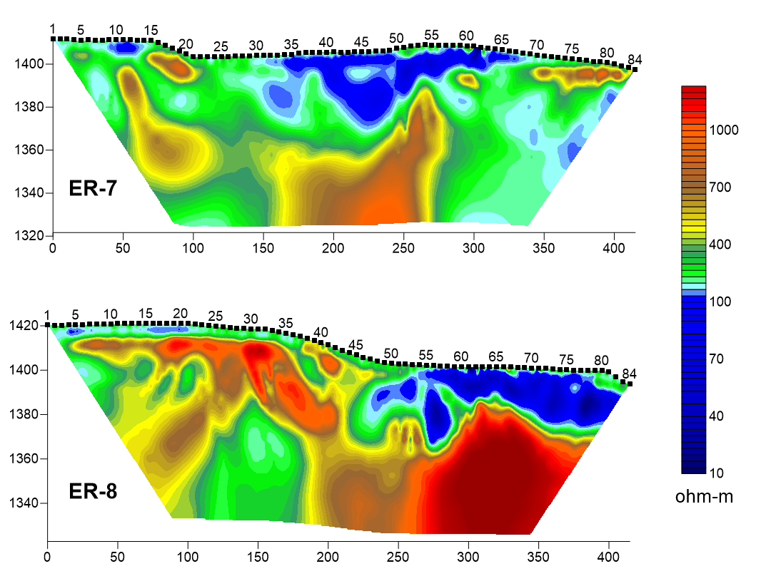
Electrical Resistivity (ER)
With ER data, you can:
Design safe electrical grounding systems
Image Karst features
Image shallow rock
Locate the best spots to drill a well
We make it easy on you

Tell us about your project.
To receive a proposal, what questions you are trying to answer and we will respond to your request shortly.

We’ll recommend the scope of work.
We’ll give you honest and straightforward recommendations of what geophysical tools and methods will get you the information you need as quickly and cost effectively as possible.
Confidently navigate your project to success
With accurate information, clear communication, and using the best technology available, we will help you ensure that your project is a success.

Don’t Take Chances with Your Project
With us on your side, you can relax.
At HydroGeo, we know that you are looking to partner with a geophysical firm that delivers the same level of professional excellence as you do. In order to do that you need a partner who has earned a reputation for technical excellence combined with friendly, honest service.
You know that there is amazing technology available in this day and age to make your job easier. We are equipped with personnel, tools and experience to provide a comprehensive set of services to ensure the successful outcome of your project.
We employ state-of-the-art techniques, tailored to your needs, that provide detailed information so you know you have everything you need to steer your project toward success. By working with an established team with a streamlined process, you'll save time and money without ever sacrificing the quality of the data you receive from us. Your surveys will be specifically tailored to your project needs - we’ve seen it all so we can get it all taken care of.